Non United States MapPacks or MapTrees - Read this!
This question comes up quite a bit, so I thought I'd make a sticky answer:
Currently WiGLE uses Census Bureau TIGER data for street-level U.S. maps. We use low-resolution VMAP0 U.S. Military data for the rest of the world. Both data sets are unencumbered by copyright or redistribution restrictions, so we can use the data sets to generate maps without legal entaglements.
The U.S. government has higher-resolution VMAP1 data sets for the rest of the world, but for the most part has not released it. There are groups trying to make that happen. It would be a good thing.
There is an arcview Canadian data set that we may write a parser for.
Other than that we have no street-level data for outside of the United States, so there are no MapPacks or MapTrees for them. If anyone finds or would be willing to donate such data we would very much appreciate it.
Other folks have set up ways to use other maps as backgrounds for JiGLE/DiGLE etc. There is a note on the NetStumbler forums for how to make MapPacks from GPSVisualizer, which takes maps from other random web sources to use. Since WiGLE does not have rights to use any of those maps, we do not package them up.
If you'd like to make your own Raster MapPacks, there are instructions in the wiki.
One note: the data for my country (the Netherlands) seems to have gone from 'major cities, railway lines, major roads' to 'it has provinces'. On the map for my city, url
http://www.wigle.net/gps/gps/Map/online ... 2109375005
I used to be able to see the 6 major railways, roads. Now I have to zoom out to see the borders of the province it is in.
Just a note that your map data for at least this country seems to have degraded.
http://www.wigle.net/gps/gps/Map/online ... 2109375005
I used to be able to see the 6 major railways, roads. Now I have to zoom out to see the borders of the province it is in.
Just a note that your map data for at least this country seems to have degraded.
Ah, true, thanks for the heads up. I forgot to turn worldwide high-level transportation systems back on after moving to the new hardware. It should appear during tonights update.
At risk of making myself look stupid... can't we use GPSDrive maps ?? or at least use the maps that GPSDrive pulls in...
It's not GPSDrive maps.At risk of making myself look stupid... can't we use GPSDrive maps ?? or at least use the maps that GPSDrive pulls in...
It's Microsoft Expedia maps, which GPSDrive lets the user pull down to the users PC, thereby letting the user decide if they want to violate the usagepolicy and copyrights for the mapserver.
Wigle can't provide ready made mappacks for these maps, since Wigle does follow the law. Feel free to make your own mappacks for your own use, with the maps GPSDrive picked up for you. Just don't redistribute them, unless you'd like a legal fight with Microsoft. Directions on making mappacks are in the wiki.
Dutch
[url=http://www.wigle.net/gps/gps/StatGroup/listusers?groupid=20041206-00006][img]http://home19.inet.tele.dk/dutch/netstumblerwigle.gif[/img][/url]
At risk of making myself look stupid as well... why doesn't the project offer the raw data for the complete world, like lon, lat & mac without any maps?
this should not lead to any copyrights issues and would be significantly beneficial for people outside the US - at least they could guess where they are...
or is it offered for download and i missed it somewhere?
this should not lead to any copyrights issues and would be significantly beneficial for people outside the US - at least they could guess where they are...
or is it offered for download and i missed it somewhere?
We only provide downloadable mappacks for the wigle clients for places we have map data for to generate maps from (the general sope of this sticky). Depending on what it is you're talking about, wigle data is available via a number of channels, downloadable clients and web queries, all of which are zero cost (other than sanity and subsequent OCWD implications) and are subject to the EULA. And of course the webmaps cover the whole globe, at varying levels of detail.
What about the Openstreetmap Project?
They have pretty good coverage. Maybe certain areas, like Europe could be rendered with their data?
They have pretty good coverage. Maybe certain areas, like Europe could be rendered with their data?
Why not indeed?What about the Openstreetmap Project?
They have pretty good coverage. Maybe certain areas, like Europe could be rendered with their data?
Every time I upload data here it's suggested I also give the data to OSM, why is this only one way? Or is it just yet another case of 'If it's not in America it doesn't exist'?
-S
Because things take time. The Wigle Triumvirate are doing this in their spare time, on their spare dime. Since they also have other stuff going on in their lives, including family, work, and kitteneating, they have to prioritize.Why not indeed?What about the Openstreetmap Project?
They have pretty good coverage. Maybe certain areas, like Europe could be rendered with their data?
Every time I upload data here it's suggested I also give the data to OSM, why is this only one way? Or is it just yet another case of 'If it's not in America it doesn't exist'?
-S
I know that they have looked at using Mapnik and Openlayers, in order to utilize OSM, but again, they don't want to implement stuff thats untested, and might break existing stuff.
Since OSM now have completed their import of TIGER data, it might be possible the Wigle Triumvirate will find more time to take a look at incorporating OSM mapdata into the visualization of Wigle data. Then again, they might not...
As for generating Mappacks for the Jigle/Digle offline clients, with OSM data, that just became easier, since OSM now have incorporated a export tab on their map interface, giving people the possibility of generating a stiched tile for download, in PNG or SVG format, aswell as for downloading the underlaying vectordataset, for the same boundingbox.
Dutch
[url=http://www.wigle.net/gps/gps/StatGroup/listusers?groupid=20041206-00006][img]http://home19.inet.tele.dk/dutch/netstumblerwigle.gif[/img][/url]
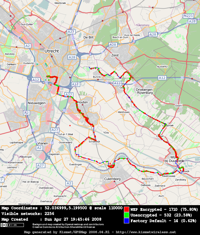
I just tested using an OSM export in kismets gpsmap, and.. succes! This means at least kismet users can now make wardriving plots that they can publish.As for generating Mappacks for the Jigle/Digle offline clients, with OSM data, that just became easier, since OSM now have incorporated a export tab on their map interface, giving people the possibility of generating a stiched tile for download, in PNG or SVG format, aswell as for downloading the underlaying vectordataset, for the same boundingbox.
The recipe with sample numbers:
Go to the mapviewer at http://www.openstreetmap.org/
Zoom, drag, click until you find the area you want. Click on 'permalink' and note down the lat and lon numbers, for example lat=52.0375&lon=5.2417.
click on the 'export' tab
Note the scale: 110000
Note the image size: 670 x 686
Click 'export'. Your browser will be asked to download map.png
Now, on the command line:
Code: Select all
mv map.png map_52.0375_5.2417_55000_670_686.png
               lat     lon    scale/2 siz siz
I'm quite happy this is now possible! The technical parts were all there, but we can now use maps with a license that allows republishing.
Patch for that purpose has been posted http://www.kismetwireless.net/Forum/Gen ... 071.685936(I would not be too surprised when gpsmap started offering the option to fetch openstreetmap plots itself complete with the appropiate message about the map source). I
Dragorn is incorporating it, AFAIK, but otherwise the patch in the above thread, applied cleanly to my last SVN checkout of Kismet-devel (Not Newcore).
Dutch
I dont know if this is the right place to ask this
if i was to create a map cache for the android device i would like to know a few things default zoom level the file extention used (is it png.x or png.tile) and are the files stored in sdcard\osmdroid\tiles\Mapnik\
thanks in advance
if i was to create a map cache for the android device i would like to know a few things default zoom level the file extention used (is it png.x or png.tile) and are the files stored in sdcard\osmdroid\tiles\Mapnik\
thanks in advance

Default zoom level is 16. For everything else, it's osmdroid defaults.
-bobzilla - WiGLE.net just a little bit

Return to “WiGLE Project Suggestions”
Who is online
Users browsing this forum: No registered users and 162 guests